Water Resource Study for Coffee Growers Near La Union, Honduras
(By Stuart Dykstra: Adapted from a newsletter article written for the American Institute of Professional Geologists – 2019)
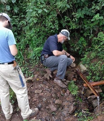
COLD WATER INTERNATIONAL organized a team of two of its own hydrogeologists, two researchers from Calvin University’s CLEAN WATER INSTITUTE and a student intern to conduct a hydrogeologic investigation and community water supply assessment for Chimizal, Honduras, a small coffee-growers community in the mountains above La Union.
Chimizal, Honduras is a small village of 83 homes with under 500 residents on the side of a steep mountain that is located at about 1,200 meters above sea level. The village was likely settled in this location due to five small springs in the area emanating from the mountainside. Water from the streams and springs is relatively abundant during the wet season but only marginally adequate for subsistence during other times of the year.
The community experiences severe water shortages during 1/3 of the year because the flow of the springs is very seasonal, and some do not flow at all during the dry season when water is critical for the coffee harvest. Right when they need it most, the volume of flow is significantly reduced. The lack of water and its poor water quality, along with poor water handling practices cause pervasive diarrheal and other water-related diseases. The objective of the study was to determine what could be done at both the source and within the engineered systems to improve the volume and quality of water available.
Little was known about these springs, their capacity, quality, or their relationship to the geology and streams prior to this study. The science team was invited by ALDEA DEVELOPMENT, an international development and micro-finance NGO working to improve the lives and livelihoods in the small, coffee-growing communities in Western Honduras. This trip was the beginning of a series of geologic, engineering, and community studies that continue to this day, to provide information of the water conditions and related health issues in the community and to evaluate possible interventions to improve the water situation.
The investigation evaluated the springs and the community water system to refine geologic maps, develop cross sections of the region, initiate a geodatabase of water data, and map and assess the community water system and the incidences of community health issues.

After the initial investigation, COLDWATER INTERNATIONAL arranged for the geologic intern to conduct an additional four weeks of mapping and surveys. This work resulted in a clearer understanding of the hydrogeology of the springs and why they’re variable over the year. The work also provided documentation of the numerous pipe and reservoir failures in the existing water system which results in a loss of a high proportion of the available water from leaks and overflows. The investigation provided the recommendations for further work and the first round of repairs that are currently in planning and fundraising.
Coffee Growing & Importance of Water in the Chimizal Region
The community of Chimizal is composed primarily of farming families cultivating small coffee fields located further up the mountain. The average small grower in Honduras farms, approximately 2.8 hectares of land and the farmers near Chimizal use the wet-process to separate the coffee bean from its fruit husk. Coffee processed in this manner requires the use of substantial quantities of water which increases the quality of the coffee and increases the “farm-gate” price per pound; sometimes several times over that of lower-quality coffee.


Unfortunately, harvest time typically occurs during the driest time of the year when water is scarce even for use in domestic activities. Most of the rainfall occurs between May and September during the growing season. During harvest, severe curtailment of all water usage is necessary for anything other than coffee washing, which exacerbates the already poor sanitation and the availability of water for cooking and cleaning.

Existing Groundwater Development
The development of groundwater resources is an atypical means for supplying water in rural Western Honduras. This is in part due to a typically plentiful surface water resource in the valleys where the more affluent populations reside. Water scarcity in Honduras is more related to high urban usage, poor quality, minimal water storage, and/or geographic factors such as remoteness high in the mountains. Due to both geologic and social circumstances, advanced groundwater knowledge exists for only localized alluvial aquifers along major rivers. There is limited knowledge on the capacity of stratigraphic aquifers and even less known about the groundwater flow between these aquifers. It was surprising for the investigation team during this investigation to find very few wells region-wide to evaluate along with the nation-wide scarcity of drillers.
In Chimizal, it is the hydrologic seasonality and the elevation where the coffee is grown and processed, along with aquifers that have small areal extents and capacity for natural storage that causes water scarcity to become a severe issue.
Observations
The field investigations were conducted over an area of approximately 3000 km2 of La Union, Lempira Department, Honduras, though a more focused effort was conducted within an approximately 30km2 area around Chimizal. Prior to conducting the field investigations, spatial and temporal data sets were collected to establish a baseline understanding of the topography, associated geology, hydrogeology, and land use practices.
Much of the geology exposed in Western Honduras consists of red beds of fine-grained silts and limestones. The fine-grained red shales and siltstones act as an aquitard, which impede the flow of water and will not yield water.
The limestones provide an aquifer in the study area but are limited in extent and do not store enough water from the wet season to keep the springs flowing well at other times of the year.
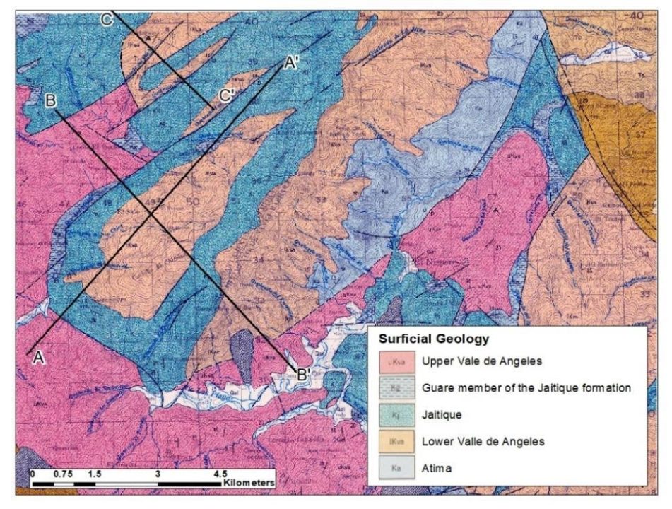
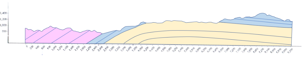


The Springs occur at the base of the limestone near the top of the mountain but not further down slope. Based on the geological data, water collects on top of the mountain and flows through the fractured limestone and causes springs where the limestone contacts the siltstones and shales. The groundwater storage is very small therefore and confined to remnants of the limestone at the axis of the anticline the mountain ridge and the reservoir function to the limestone is very limited.
Water Quality
Seventy-seven (77) water points were collected at springs and rivers in the investigation area. Water flow was measured or estimated, and water geochemistry was obtained using a field meter.

Streams were often recorded to have low total dissolved solids during precipitation events. When the weather was dry, streams would lose much of their flow but exhibit higher total dissolved solids, indicating a larger component of groundwater in the streams in the dry season.
Conclusions
Data from this study, along with previously published information, support a stratigraphic and structural interpretation of the hydrogeology in the area that demonstrates its strong influences on the availability of water during the dry season. Unfortunately, this implies a very limited opportunity to increase flow from the existing springs. The best opportunities for improving the water situation in the Chimizal area include improving the spring caps, improving the engineered water distribution system to minimize losses and contamination, identify non-potable water storage opportunities and provide overall improvements to water handling practices. Point of use filtration is strongly encouraged for the drinking water uses
The author wishes to thank the rest of the investigation team for their scientific contributions, figures, writing, and photographs that contributed to this article. The team included:
Thomas Timmermans P.G.
Dr. C. Renee Sparks
Dr. Cheryl Verbree, and
Issac Jacques
References
Finch, R.C., 1981, Mesozoic stratigraphy of Central Honduras, AAPG Bulletin, v. 65, n. 7, p. 1320-1333.
French, Christopher D., and Schenk, Christopher J. 2004, “Faults of the Caribbean Region (flt6bg).” U.S. Geological Survey, Central Energy Resources Team. https://pubs.usgs.gov/of/1997/ofr-97-470/OF97-470K/graphic/data.html. Accessed June 2017.
Kozuch, M.J., 1989, Geologia Honduras – La Union. 1:50,000 geologic map, HOJA 2560 III G
Rogers, R., Mann, P., Emmet, P. A., Venable, M. E., 2007, Colon fold belt of Honduras: Evidence for Late Cretaceous collision between the continental Chortis block and intra-oceanic Caribbean arc: The Geological Society of America, Special Paper 428, p. 129-149.